 |
      |
| Home > California > Knoxville |
Knoxville Recreation Area
Wednesday, January 31, 2024
| Other Names | Rocksville, Hunting Creek Camp, Jericho Creek, Morgan Valley Road, Devilhead Road |
| Last Known Status | Open |
This large area of public land offers 51 miles of rugged 4x4 roads and some single track motorcycle trails. There are two entrances to this area, Hunting Creek Camp (Lower Camp) and the Northern Staging Area (Upper Camp). The Upper Camp is dry and rocky, (bear right at the fork!) and offers only two campsites, both primitive. Upper Camp is accessible by large vehicles and trailers but there is no room to camp or park.
While the Upper Camp does have more trails, Lower Camp offers more room for RVs and trailers, but the road is steep and rocky. This camp has five developed sites with tables, fire rings and direct access to the creek. Look for an opening in at the back of the campground to find a motorcycle trail that follows the creek and leads to two great swimming holes (first hole is 1/4 mile in, waterfall is 1/4 mile past that).
You can ride from the Lower Camp to the Upper Camp by following the main access road right through the campground, across the curved bridge and up over the ridge (make no turns). Follow the road about 7 miles to the Upper Camp area.
Many locals playfully call this place "Rocksville" because of the many rocks, but we've seen bigger chunk. As long as you use a skid and guards you'll have no problems.
REGULATIONS
| Permit Required | Yes | CA OHMVR stickers required |
| Dates Open | Year-Round | CA OHMVR red sticker vehicles permitted year round |
| Other ATV Stickers Accepted | Yes | Residents of any state not listed must purchase a Nonresident OHV Use Permit. (AR, AZ, CA, CO, CT, DE, IA, ID, IN, LA, MA, MD, ME, MI, MN, MO, MT, ND, NH, NJ, NM, NV, NY, OH, OK, OR, PA, RI, TX, UT, VT, WA, WI, WY) |
| Spark Arrestor | Yes | A spark arresting exhaust silencer or end cap is required for all vehicles. |
| Noise Limit | Yes (96 dB) | CA OHMVR noise limits apply (1985/older limit 101 dB, 1986/newer limit 96 dB) |
| Whip Flags | Not Required | |
| Maximum Vehicle Width | No Restriction | |
 Motorcycles & Dirt Bikes Motorcycles & Dirt Bikes | Permitted | CA OHMVR stickers required |
 ATVs ATVs | Permitted | CA OHMVR stickers required |
 UTV & SXS UTV & SXS | Permitted | CA OHMVR stickers required |
 SUVs & Jeeps (registered) SUVs & Jeeps (registered) | Permitted | |
| Dune Buggy & Sand Rail 4x4 (unregistered) | Permitted | CA OHMVR stickers required |
| 2 Stroke Engines | Certain Times | CA OHMVR restrictions apply |
| MX Helmet Required | Yes | helmets required by state law |
 Camping Camping | Some Areas | (camp in developed sites only) |
 Campfires Campfires | Some Areas | (permitted in developed campsites only) |
| Night Riding | Unknown | Not Recommended |
| Trail Blazing | Prohibited | stay on trail |
| Alcohol | No Restriction | |
| Rule Enforcement | Few/Periodic | Jeep/SUV Patrol |
TERRAIN
| Approx Size | 24,000 acres (38 sq mi) | |
| Miles Of Trail | 51 | |
| Climate Type | Forest | |
| Elevation | 1000 to 2200 ft. | |
| Trail Maintenance | Not Marked, Not Rated, Not Maintained | |
| Loose Dirt |  Little Little | |
| Hard Pack |  Mostly Mostly | |
| Sand |  None None | |
| Mud | Little | |
| Dust |  Some Some | |
| Rocks | Mostly | mostly small rocks, bigger ones are well spaced & avoidable |
| Trees | Some | |
| Steep Hills |  Few Few | |
| Water Crossings | Few | |
| Small Jumps | None | |
| Large Jumps | None | |
| Berms | Few | |
| Sand/Gravel Pits | None | |
| Single Track | Few | |
| Roads | Mostly | |
| Intersections | Some | |
| Rider Traffic | Few | |
| Shade | Some | |
| Ranges/Gunfire | Some | |
| Hazards | Some | (hazards not marked) Beware of cliffs. few cliffs |
 Novice Novice | Little | |
 Amateur Amateur | Mostly | |
 Expert Expert | Little |
TYPE OF AREA
| Area | Motorized Trails |
| Land | BLM |


KEY SERVICES
 Gasoline Gasoline | 5-20 Miles (W) | Shell (707) 987-9794 |
| Diesel | 5-20 Miles (W) | Shell (707) 987-9794 |
 Water Water | 30+ Miles (NW) | Edgewater Resort & RV Park (707) 279-0208 |
 RV Hookup RV Hookup | 30+ Miles (NW) | Edgewater Resort & RV Park (707) 279-0208 |
 RV Disposal RV Disposal | 30+ Miles (NW) | Edgewater Resort & RV Park (707) 279-0208 |
| Campground | On Site | 1-2 sites at Upper Camp, 4-5 at Lower Camp |
 Conv Store Conv Store | 5-20 Miles (W) | Tower Mart (707) 994-5846 |
FEES & PASSES
| Parking | (None) |
| Entry | (None) |
| Riding | (None) |
| Camping | (None) |
RATINGS
| Pros | swim holes, waterfalls, scenery decent, secluded, campsites at lower camp very nice |
| Cons | dry, rocky, rough entrance, no signs or directions, not enough camp sites, no turn around in northern area |
| Our Rating |  Very Good Very Good |
| Recommended Stay | 1-2 Days Late Spring |
| Comments | (Scroll Down For Rider Reviews & Comments) |
DRIVING DIRECTIONS
| Nearest City | Lower Lake, CA | ||
| Address | Berryessa Knoxville Road, Napa, CA 94558 | ||
| From: Lower Lake, CA
For Upper Camp Staging Area: 1) Take Morgan Valley Road east about 13 miles 2) Turn right (south) onto Dunnigan Hill Road (look for a BLM entrance sign), continue .8 miles 3) Turn right (west) onto dirt road, continue .4 miles 4) Upper Camp entrance on right (north). For Lower Camp Staging Area: 5) Continue east on Morgan Valley Road about 4 miles (road name changes to Berryessa Knoxville Road) 6) Veer right (south) onto Knoxville Devilhead Road, continue .6 miles 7) Lower Camp entrance on the right (turn is at: N 38º 49.013' W 122º 21.182').* *Note: There is a large, flat staging area just prior to turning into entrance road for Lower Camp. |

OFFICIAL CONTACTS
| Contact Info | BLM - Ukiah Field Office 2550 North State Street Ukiah, CA 95482 (707) 468-4000 blm_ca__web_uk@blm.gov www.blm.gov |
Knoxville Trail Photo
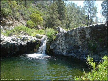
This waterfall makes for a nice refreshing dip after a long day of riding. To get to this swimming hole take the single track motorcycle trail from Hunting Creek camp for about a half mile.
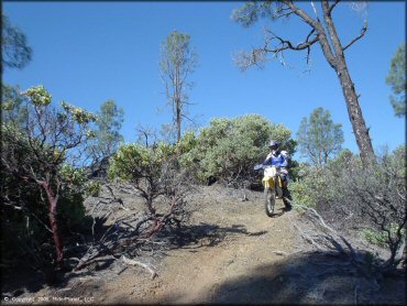
Knoxville Trail Photo
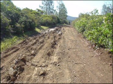
Most of the motorized trails are wide and rutted but some of the rough sections can be avoided if you choose the right line.
Knoxville Trail Photo
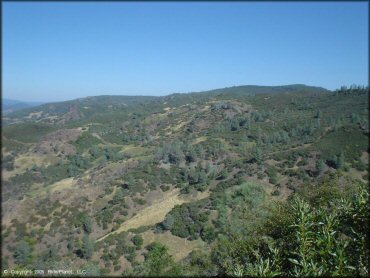
The views from the top of the trails are very scenic.
Knoxville Trail Photo
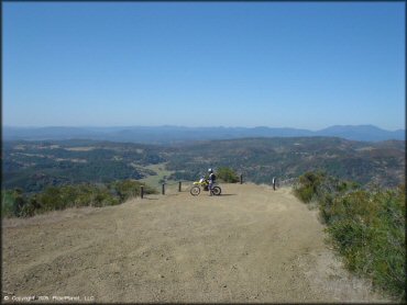
Some of the off-road trails lead to a scenic viewpoint.
Knoxville Trail Photo
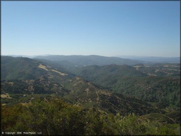
Another view taken from the scenic view point.
Knoxville Trail Photo
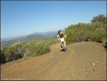
A good portion of the terrain look like this - wide and hard packed 4x4 trails.
Knoxville Trail Photo
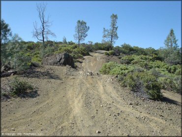
Some sections of the 4x4 trails have some loose chunk rock.
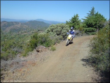
Knoxville Trail Photo
Some of the off-road trails have some light to moderate elevation changes.
Knoxville Trail Photo
Another view of a hard packed ATV trail covered with some light gravel.
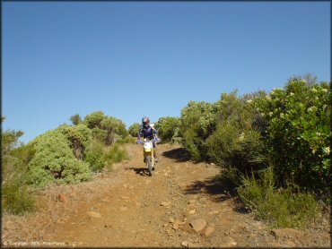
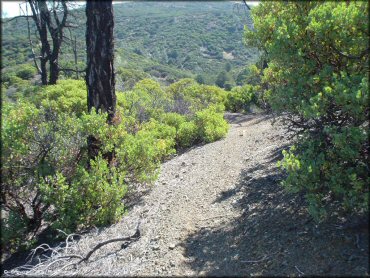
Knoxville Trail Photo
This is one of the narrow side routes that are open to dirt bikes.
Knoxville Trail Photo
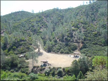
Hunting Creek Camp has five sites that come with a picnic table, shade gazebo and fire ring plus three overflow campsites. There is no fee charged to camp or park but sites are first come, first serve.
Knoxville Trail Photo
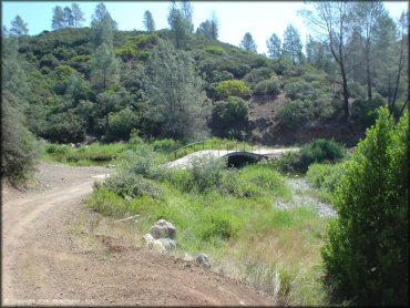
This small bridge leads out of Hunting Creek Camp. The main road heads north and eventually ties into the upper camp area.
Knoxville Trail Photo
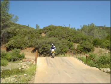
Another view of the small bridge that leads out of the Hunting Creek camp. Stay on this main road to access the northern staging area.
Knoxville Trail Photo
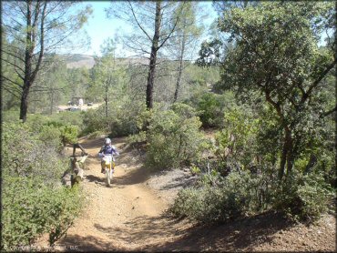
This is the trail to take from Hunting Creek camp to access the waterfall.
Knoxville Trail Photo
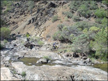
This is one of the shallow stream crossings that you need to cross to access the waterfall.
Knoxville Trail Photo
This is a good view of the type of terrain you will find here - wide and hard packed 4x4 trails.
RIDER COMMENTS & REVIEWS